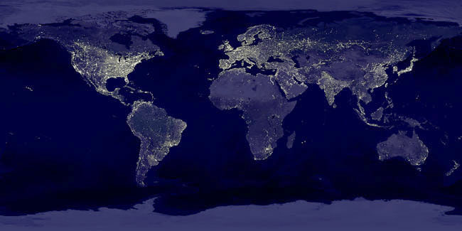
J. Vernon Henderson, Adam Storeygard and David Weil, were looking for a way to track economic growth in regions which have poor geographic connections, poor statistics, or have other impediments to useful growth tracking. Using light as a proxy for economic activity, they estimated the growth in productivity in remote regions using nighttime satellite pictures. This idea - trying to get a handle on economic activity from space - has even seen inroads commercially now; witness the new SpaceKnow satellite activity index, with an eye on trying to see Chinese economic activity.
Light and Intensity
The report (Measuring Growth from Outer Space) concentrates on two variables of light- both the amount and the intensity of the light. By checking the pixels covered and the intensity of light coming from certain regions, the authors were able to come up with an (admittedly error prone) method of showing where economic growth was highest. As they state in the paper, "Several error-prone measures are better than one". Any insight into economic growth in remote areas should be considered a good thing.
Sniff Testing the Data on Economic Activity from Space
Does the paper pass muster? Several example correlations were highlighted in the WSJ blog entry linked above... Moldova, Ukraine, Hungary, Poland, and Romania all had light measurements correlating with economic growth. The paper certainly details an interesting way to get data on regions which don't have accurate numbers now...

Can you see Economic Activity from Space? Satellite Image of the Earth at Night (NASA)
Another reason I tend to believe that the data is useful is by looking at the concentrations of light as they are currently in the United States: both coasts light up like a Christmas tree at night.
On the West Coast, San Diego, Los Angeles, San Francisco, Portland and Seattle all host pockets of light in the surrounding area. The East Coast defines the term 'light pollution'. From Portland, Maine all the way down to Washington, D.C. there is a solid band of light. New York, Philadelphia, Cleveland and Chicago provide another band. In fact, the entire East Coast stretching to the Mississippi River has significant light coverage.
Knowing the productivity of the regions mentioned, I feel that this may be a somewhat inaccurate, yet still interesting way to gain insight into the growth of other economies, and SpaceKnow is certainly betting you can see economic activity from space - their method is more advanced, looking at known industrial areas and trying to spot areas of construction.
What do you think? Is it a good idea?
