
Track the sun's position across Earth in real-time with this interactive solar tracker map. Click to get instant sun data, watch the day/night terminator sweep across continents, and see where the sun and moon are right now with astronomical precision!
How to use the solar tracker map
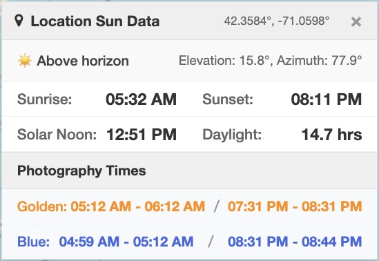
Click anywhere on the map for instant sun data. A draggable panel shows sunrise, sunset, solar noon, daylight hours, and photography times for that exact spot. The map displays:
- Sun position – The subsolar point where the sun is directly overhead
- Moon position – Current lunar location in relation to the earth
- Terminator line – Moving boundary between day and night
- Your clicked location – Red marker with a location, and detailed sun calculations for the latitude and longitude and your choice of date
Search for any city in the Search for a city... box, or click the location arrow button to use your current position. (Tap and hold on mobile.)
Customization options
The date picker lets you see sun positions for any date and your choice of location. Click Now to snap back to real-time. The terminator updates every 30 seconds, so you can watch Earth's rotation happen.
Your sun data panel shows:
- Sun status – Is it day, night, or twilight at your location and date/time selection?
- Elevation – How high the sun is above the horizon (0° = sunrise/sunset, 90° = directly overhead)
- Azimuth – Compass direction to the sun (0° = north, 90° = east, 180° =
south, 270° = west) - Local sun times – Sunrise, sunset, solar noon
- Photography times – Golden hour (warm light) and blue hour (even, diffused light)
Don't like where it popped up? Don't worry, you can drag it anywhere.
Advanced features
Photographers get dedicated golden and blue hour times. Golden hour is when the sun creates a warm, yellow light between -4° and +6° elevation. Blue hour delivers even blue lighting when the sun is between -6° and -4° below the horizon.
Traditionally, photographers prize golden hour for portraits and blue hour for cityscapes, but your mileage may vary. Check out the links to the dedicated tools, above.
The tool calculates the subsolar point (where the sun is directly overhead) using Earth's 23.5° axial tilt and orbital mechanics. Moon position uses an independent 27.3-day orbit – the moon doesn't just hide behind Earth during the day, after all.
Related tools on DQYDJ
- Sunrise Sunset Calculator – Daily sun times, no map needed
- Golden Hour Calculator – Photography timer with countdowns
- Blue Hour Calculator – Peak blue hour tracking
- Solar Panel Angle Calculator – Optimize panel tilt
- Daylight Hours Graph – Annual daylight visualization
- Hours Between Times Calculator – Calculate time spans
- Days Between Dates Calculator – Date differences
- Time Zone Converter – Convert between zones
- Moon Phase Calendar – Lunar cycle tracking
- Sun Angle Calculator – Precise solar angles
Solar Tracker Map
Whether you're chasing the perfect light for photography or wondering if it's bedtime in Tokyo, this map puts real-time solar data at your fingertips. The sun never sets on a good data visualization!
PS: you don't have to chase the perfect light. Weather permitting, it'll be back within 24 hours. The tool will show you!
