
Our shadow length calculator shows real-time shadow length and direction for any object height, location, date, and time. See an interactive polar diagram with animation or a table mode, and use CSV/SVG export options for whatever it is you do where you need to predict shadows.
Shadow length calculator
Using the shadow calculator
The shadow calculator detects your location (with permission) or lets you enter a city or latitude and longitude. Switch between Visualization and Table modes to see shadow data your way, and click Animate to watch shadows sweep through the day.
Basic shadow features
- Object Height: Enter height of an object in feet/inches or meters
- Location Search: Type a city name (in the US you can do "City, State") to search 150,000+ locations worldwide, or directly enter a latitude and longitude
- Date & Time: Pick any date and time, with seasonal presets for solstices and equinoxes
- Visualization Mode: Interactive polar diagram shows shadow direction, length, and sun position with a compass rose
- Table Mode: Complete 24-hour shadow data with hourly breakdown
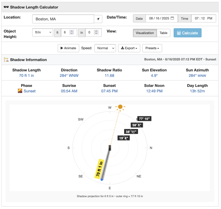
Interactive shadow diagram
The visualization shows a top-down polar view with the object at center. Watch as the shadow length and direction update in real-time when you change the time or date (or start the animation). The diagram includes:
- Shadow projection: Realistic shadow (with width) showing how shadows actually spread
- Sun indicator: Shows where the sun is in the sky with rays and a connection line to the object
- Distance rings: High-contrast labels showing scale. The rings are mostly fixed through the day, though automatically adjust for sunrise/sunset when shadows get extremely long
- Compass rose: Cardinal directions and degree markers for precise shadow bearing
During nighttime, the diagram shows "NO SHADOW" with the appropriate phase emoji. That's because shadows don't exist when the sun's below the horizon (I mean, I'm ignoring artificial light here folks. Don't shade me.).
Shadow animation and speed controls
Hit Animate to watch shadows sweep through a complete day. The animation steps through 15-minute intervals, showing how shadow length and direction change from sunrise to sunset. Speed options let you watch at slow, normal, or fast rates.
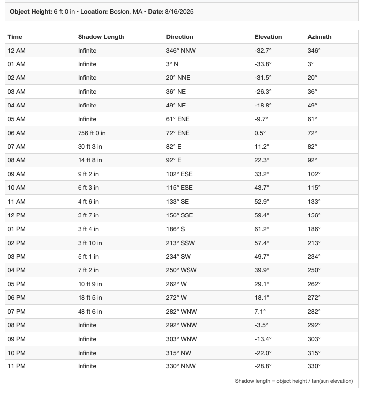
Table mode: hourly data
Switch to Table mode to see a complete 24-hour breakdown of shadow data. The table shows object height, location, and date at the top, followed by hourly shadow calculations from midnight to 11 PM.
Each row includes shadow length, compass direction, sun elevation, and azimuth for that hour. During nighttime hours, you'll see "Infinite" shadow length (the sun's below the horizon). The formula appears at the bottom:
\text{Shadow Length} = \frac{\text{Object Height}}{\tan(\text{Sun Elevation})}Table mode is perfect for analyzing patterns, finding the shortest shadow time (solar noon), or exporting precise data.
Export options
- CSV Export: Export the complete 24-hour shadow data with object height, location, and date metadata for spreadsheet analysis
- SVG Export: Download a scalable diagram with embedded metadata
Related solar and astronomy tools
Explore more sun tracking and solar calculation tools:
- Sun Angle Calculator - Hour-by-hour solar position data with visual mode
- Sunrise Sunset Calculator - Precise dawn and dusk times
- Solar Panel Angle Calculator - Optimize panel tilt for maximum energy
- Sun Path Diagram Generator - Visual sun trajectory charts
- Golden Hour Calculator - Perfect photography lighting times
- Solar Noon Calculator - When the sun reaches its highest point
- Daylight Hours Graph - Compare daylight patterns through the year
- Analemma Calculator - Figure-8 sun position pattern
- Solar Tracker Map - Real-time sun position tracking
- Blue Hour Calculator - Twilight photography planning
